Data for 2004
Burned Area, 2004
2004, as GWIS’s 2026 release gives it · stored as published, never rewritten
Burned Area, 2004 covers 209 countries on 6 measures. Australia is highest, at 63,991,467.79; 53 countries share the lowest reading, 0.00. The middle country reads 20,585.77. Against 2003, 164 values changed (75 up, 89 down), the same countries are covered.
Burned Area · Data for 2004
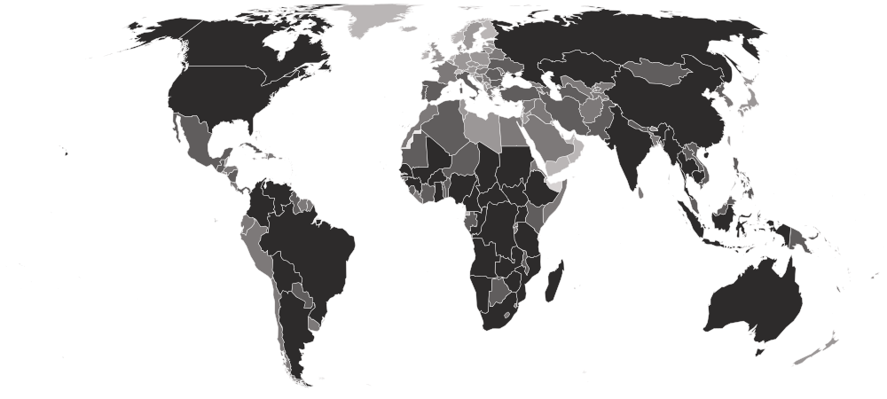
HighestAustralia
63,991,467.79Lowest53 countries share it
0.00Shaded by value in five groups of equal size, darkest at the highest end. Neither end is better. The values describe a shape, not a score.
01Values only
The table
Every country and every column of Burned Area, 2004, as published. The file carries values only, so no position is shown. “=” marks a shared position.
Showing 25 of 209 countries · select a heading to sort
| AustraliaAUSAustralia and New Zealand | 63,991,467.79 | 135,771.610 | 5,078,995.938 | 57,906,667.174 | 858,140.978 | 11,892.092 |
 AngolaAGOMiddle Africa | 41,219,080.46 | 2,579,703.548 | 22,343,993.038 | 16,071,924.190 | 219,209.439 | 4,250.244 |
 DR CongoCODMiddle Africa | 37,714,176.57 | 5,343,455.424 | 29,934,087.603 | 2,341,561.213 | 58,065.172 | 37,007.162 |
 South SudanSSDEastern Africa | 31,821,087.61 | 240,932.897 | 17,452,565.845 | 12,909,078.905 | 1,178,282.926 | 40,227.036 |
 ZambiaZMBEastern Africa | 25,136,552.13 | 3,274,274.607 | 16,160,148.909 | 5,598,212.344 | 80,303.811 | 23,612.455 |
 Central African RepublicCAFMiddle Africa | 21,255,630.65 | 2,948,143.695 | 14,840,362.991 | 3,186,908.530 | 278,562.564 | 1,652.871 |
 BrazilBRASouth America | 20,506,858.29 | 2,834,138.482 | 9,880,953.399 | 6,311,608.980 | 1,432,073.879 | 48,083.545 |
 MozambiqueMOZEastern Africa | 19,486,499.72 | 3,172,805.453 | 13,384,397.603 | 2,838,431.640 | 87,688.066 | 3,176.954 |
 TanzaniaTZAEastern Africa | 14,959,069.25 | 1,555,202.095 | 9,442,920.915 | 3,855,677.622 | 99,429.903 | 5,838.717 |
 KazakhstanKAZCentral Asia | 13,425,740.86 | 171.728 | 24,320.827 | 12,542,098.432 | 855,500.676 | 3,649.199 |
 ChadTCDMiddle Africa | 12,700,108.69 | 218,694.258 | 1,035,534.908 | 8,291,964.029 | 3,153,292.980 | 622.511 |
 NigeriaNGAWestern Africa | 10,600,253.15 | 40,656.356 | 1,267,559.474 | 4,778,151.802 | 4,511,867.727 | 2,017.793 |
 RussiaRUSEastern Europe | 10,476,094.64 | 1,249,313.504 | 3,726,603.380 | 1,600,301.892 | 3,890,044.485 | 9,831.375 |
 MaliMLIWestern Africa | 9,572,617.68 | 171.728 | 217,363.375 | 8,109,804.677 | 1,238,752.272 | 6,525.624 |
 SudanSDNNorthern Africa | 9,546,450.78 | 64.398 | 382,672.018 | 7,748,770.249 | 1,414,901.182 | 42.932 |
 EthiopiaETHEastern Africa | 6,720,147.36 | 203,625.216 | 4,315,347.708 | 1,115,538.195 | 1,084,820.537 | 815.704 |
 BoliviaBOLSouth America | 6,495,807.60 | 2,371,355.837 | 2,963,663.513 | 968,539.940 | 174,903.890 | 17,344.422 |
 GhanaGHAWestern Africa | 5,448,552.31 | 2,962.291 | 1,696,275.766 | 2,684,478.434 | 1,063,676.658 | 1,159.156 |
 MyanmarMMRSouth-eastern Asia | 5,409,398.58 | 3,439,218.332 | 1,455,342.879 | 107,608.395 | 405,146.783 | 2,082.191 |
 SenegalSENWestern Africa | 4,848,066.14 | 1,760.200 | 245,397.796 | 3,894,509.378 | 706,291.435 | 107.330 |
 ArgentinaARGSouth America | 4,785,493.16 | 169,494.495 | 2,171,508.614 | 1,839,152.587 | 572,580.548 | 32,756.914 |
 CameroonCMRMiddle Africa | 4,734,232.65 | 173,594.474 | 2,762,442.468 | 390,829.051 | 1,405,069.812 | 2,296.849 |
 CambodiaKHMSouth-eastern Asia | 4,185,672.42 | 1,562,586.351 | 1,996,754.986 | 152,257.397 | 468,342.299 | 5,731.389 |
 IndiaINDSouthern Asia | 4,027,039.65 | 853,525.820 | 457,845.489 | 261,153.742 | 2,454,128.215 | 386.387 |
 ColombiaCOLSouth America | 3,982,412.12 | 167,541.096 | 2,947,714.380 | 850,177.142 | 13,416.169 | 3,563.338 |
 United StatesUSANorthern America | 3,961,182.39 | 270,748.983 | 2,140,769.493 | 735,055.701 | 803,982.606 | 10,625.608 |
 Burkina FasoBFAWestern Africa | 3,761,313.68 | 0.000 | 42.932 | 3,399,463.548 | 361,742.798 | 64.398 |
 GuineaGINWestern Africa | 3,683,263.78 | 22,496.229 | 2,932,409.207 | 439,062.850 | 287,084.506 | 2,210.986 |
 NamibiaNAMSouthern Africa | 3,670,577.45 | 0.000 | 450.783 | 3,653,748.213 | 16,206.730 | 171.727 |
 MadagascarMDGEastern Africa | 3,556,743.97 | 69,420.620 | 202,766.586 | 3,273,974.088 | 7,212.530 | 3,370.142 |
 ZimbabweZWEEastern Africa | 3,552,236.13 | 17,086.832 | 409,117.962 | 2,657,087.994 | 468,149.103 | 794.237 |
 Republic of the CongoCOGMiddle Africa | 3,266,461.05 | 53,900.793 | 1,118,457.560 | 2,058,920.133 | 13,265.910 | 21,916.652 |
 UgandaUGAEastern Africa | 3,181,692.34 | 9,487.918 | 1,601,718.627 | 467,505.122 | 1,098,708.958 | 4,271.714 |
 South AfricaZAFSouthern Africa | 3,153,013.94 | 17,194.161 | 104,302.653 | 2,802,776.837 | 227,709.924 | 1,030.364 |
 VenezuelaVENSouth America | 2,521,509.58 | 23,032.878 | 1,138,399.346 | 1,316,201.123 | 41,643.786 | 2,232.451 |
 IndonesiaIDNSouth-eastern Asia | 2,453,312.53 | 537,548.257 | 1,483,162.640 | 108,037.712 | 259,608.202 | 64,955.715 |
 ThailandTHASouth-eastern Asia | 2,441,463.40 | 706,355.849 | 684,525.055 | 103,894.807 | 945,549.997 | 1,137.692 |
 CanadaCANNorthern America | 2,320,116.82 | 167,562.566 | 2,011,845.487 | 99,215.241 | 24,664.279 | 16,829.243 |
 ChinaCHNEastern Asia | 2,249,730.23 | 171,705.473 | 692,875.262 | 80,475.542 | 1,302,806.423 | 1,867.533 |
 BeninBENWestern Africa | 2,083,412.69 | 6,504.160 | 436,937.732 | 832,811.255 | 805,249.080 | 1,910.463 |
 Côte d’IvoireCIVWestern Africa | 2,028,481.54 | 7,083.739 | 1,654,546.122 | 353,006.192 | 13,523.498 | 321.989 |
 ParaguayPRYSouth America | 1,914,798.31 | 94,428.358 | 1,592,660.030 | 113,382.710 | 113,490.042 | 837.172 |
 BotswanaBWASouthern Africa | 1,787,698.89 | 0.000 | 965.964 | 1,786,196.284 | 214.659 | 321.987 |
 LaosLAOSouth-eastern Asia | 1,412,668.74 | 974,142.528 | 400,338.430 | 30,116.616 | 7,792.113 | 279.056 |
 MongoliaMNGEastern Asia | 1,407,323.73 | 21.466 | 5,709.920 | 1,401,420.614 | 171.727 | 0.000 |
 UkraineUKREastern Europe | 1,141,018.20 | 2,554.442 | 8,049.707 | 24,814.544 | 1,105,363.383 | 236.126 |
 Sierra LeoneSLEWestern Africa | 1,075,096.50 | 7,663.318 | 883,384.839 | 4,894.216 | 172,929.029 | 6,225.102 |
 VietnamVNMSouth-eastern Asia | 1,035,255.89 | 245,290.476 | 452,736.624 | 18,031.334 | 318,703.738 | 493.716 |
 MexicoMEXCentral America | 955,488.71 | 100,030.947 | 383,165.732 | 114,391.610 | 356,505.134 | 1,395.285 |
 TogoTGOWestern Africa | 842,170.37 | 4,400.504 | 355,904.082 | 294,361.437 | 187,504.350 | 0.000 |
 Papua New GuineaPNGMelanesia | 690,514.03 | 89,040.421 | 462,074.261 | 74,894.412 | 43,983.565 | 20,521.370 |
 Guinea-BissauGNBWestern Africa | 623,218.53 | 45,292.983 | 555,000.001 | 20,006.191 | 472.250 | 2,447.109 |
 CubaCUBCaribbean | 509,105.98 | 6,418.300 | 152,042.736 | 14,553.858 | 333,987.431 | 2,103.656 |
 MalawiMWIEastern Africa | 473,665.85 | 68,454.663 | 261,862.123 | 84,210.601 | 57,614.383 | 1,524.076 |
 GabonGABMiddle Africa | 431,184.88 | 14,017.213 | 62,744.735 | 353,027.654 | 1,202.088 | 193.193 |
 TürkiyeTURWestern Asia | 408,388.14 | 536.648 | 1,373.816 | 22,324.507 | 384,067.303 | 85.864 |
 IranIRNSouthern Asia | 293,052.03 | 0.000 | 128.796 | 66,608.589 | 226,293.178 | 21.466 |
 GambiaGMBWestern Africa | 272,251.59 | 0.000 | 3,005.222 | 116,538.193 | 151,527.556 | 1,180.623 |
 TurkmenistanTKMCentral Asia | 268,924.39 | 0.000 | 0.000 | 234,364.342 | 34,560.047 | 0.000 |
 MauritaniaMRTWestern Africa | 264,523.88 | 0.000 | 0.000 | 264,523.885 | 0.000 | 0.000 |
 PakistanPAKSouthern Asia | 261,196.68 | 214.658 | 1,524.079 | 23,870.048 | 235,587.897 | 0.000 |
 AzerbaijanAZEWestern Asia | 252,524.47 | 0.000 | 64.398 | 68,197.062 | 184,263.006 | 0.000 |
 NigerNERWestern Africa | 201,865.02 | 0.000 | 21.466 | 180,163.023 | 21,680.526 | 0.000 |
 SpainESPSouthern Europe | 200,276.55 | 6,310.968 | 41,450.594 | 55,446.339 | 96,875.459 | 193.193 |
 KenyaKENEastern Africa | 187,439.96 | 150.262 | 34,989.369 | 123,900.982 | 27,991.498 | 407.853 |
 ItalyITASouthern Europe | 166,682.46 | 1,588.475 | 5,323.536 | 1,931.928 | 157,795.590 | 42.932 |
 NepalNPLSouthern Asia | 163,612.84 | 115,164.378 | 30,588.863 | 11,291.045 | 6,568.556 | 0.000 |
 GuatemalaGTMCentral America | 150,797.73 | 7,276.932 | 45,808.166 | 6,225.103 | 91,487.531 | 0.000 |
 BulgariaBGREastern Europe | 129,675.31 | 0.000 | 515.182 | 5,280.606 | 123,879.518 | 0.000 |
 RomaniaROUEastern Europe | 121,990.53 | 450.783 | 3,906.787 | 2,318.315 | 115,164.382 | 150.261 |
 NicaraguaNICCentral America | 113,704.71 | 2,082.190 | 62,766.195 | 10,754.401 | 32,735.452 | 5,366.468 |
 AlgeriaDZANorthern Africa | 109,175.40 | 3,048.155 | 4,336.108 | 55,682.461 | 45,979.884 | 128.795 |
 PortugalPRTSouthern Europe | 107,672.79 | 3,069.621 | 31,254.304 | 64,698.125 | 8,414.617 | 236.125 |
 North KoreaPRKEastern Asia | 101,190.11 | 72,726.361 | 15,391.030 | 2,854.962 | 9,058.596 | 1,159.157 |
 PhilippinesPHLSouth-eastern Asia | 99,837.77 | 10,539.747 | 43,919.170 | 13,008.319 | 32,091.482 | 279.057 |
 MalaysiaMYSSouth-eastern Asia | 98,828.86 | 17,752.273 | 24,320.830 | 4,185.843 | 51,260.491 | 1,309.420 |
 PanamaPANCentral America | 97,175.99 | 3,928.254 | 83,244.637 | 6,182.170 | 3,584.800 | 236.125 |
 GuyanaGUYSouth America | 80,024.76 | 1,395.282 | 8,500.483 | 65,170.374 | 4,829.821 | 128.796 |
 Sri LankaLKASouthern Asia | 78,114.30 | 279.057 | 58,129.576 | 6,869.080 | 12,836.590 | 0.000 |
 Saudi ArabiaSAUWestern Asia | 76,955.14 | 0.000 | 0.000 | 25,930.769 | 51,024.367 | 0.000 |
 BurundiBDIEastern Africa | 68,132.66 | 343.455 | 42,802.939 | 6,783.213 | 18,181.591 | 21.466 |
 FranceFRAWestern Europe | 67,123.77 | 2,726.168 | 5,151.810 | 2,425.644 | 56,755.754 | 64.398 |
 EswatiniSWZSouthern Africa | 66,200.74 | 4,271.709 | 9,208.857 | 41,107.136 | 11,570.102 | 42.932 |
 UzbekistanUZBCentral Asia | 63,882.42 | 0.000 | 0.000 | 47,074.644 | 16,807.777 | 0.000 |
 HondurasHNDCentral America | 59,803.91 | 3,327.210 | 36,427.578 | 6,590.021 | 12,214.083 | 1,245.021 |
 SerbiaSRBSouthern Europe | 59,009.67 | 0.000 | 0.000 | 42.932 | 58,966.739 | 0.000 |
 ChileCHLSouth America | 57,571.46 | 19,469.546 | 17,108.298 | 15,176.370 | 5,795.783 | 21.466 |
 GreeceGRCSouthern Europe | 54,823.83 | 257.591 | 1,481.146 | 1,609.941 | 51,346.356 | 128.796 |
 SurinameSURSouth America | 51,883.00 | 965.964 | 15,519.822 | 28,828.659 | 6,332.431 | 236.124 |
 UruguayURYSouth America | 49,607.63 | 1,567.010 | 22,947.017 | 21,272.679 | 3,498.936 | 321.988 |
 BahamasBHSCaribbean | 47,053.18 | 10,217.752 | 34,431.253 | 1,073.293 | 0.000 | 1,330.886 |
 PeruPERSouth America | 45,164.19 | 17,923.999 | 9,251.793 | 14,661.188 | 2,812.028 | 515.181 |
 IraqIRQWestern Asia | 43,940.63 | 0.000 | 0.000 | 15,283.702 | 28,656.931 | 0.000 |
 LesothoLSOSouthern Africa | 36,985.69 | 0.000 | 0.000 | 36,985.688 | 0.000 | 0.000 |
 Costa RicaCRICentral America | 32,091.47 | 2,232.450 | 14,704.121 | 5,280.602 | 9,809.902 | 64.398 |
 LiberiaLBRWestern Africa | 31,554.82 | 7,448.655 | 22,303.035 | 300.523 | 1,094.759 | 407.852 |
 AfghanistanAFGSouthern Asia | 28,935.99 | 0.000 | 0.000 | 21,981.051 | 6,954.942 | 0.000 |
 RwandaRWAEastern Africa | 26,725.01 | 0.000 | 1,760.201 | 22,388.901 | 42.932 | 2,532.973 |
 SyriaSYRWestern Asia | 25,479.99 | 665.442 | 472.249 | 5,924.581 | 17,602.011 | 815.703 |
 EcuadorECUSouth America | 23,827.12 | 493.716 | 15,197.835 | 1,674.338 | 5,946.045 | 515.182 |
 TajikistanTJKCentral Asia | 23,397.80 | 0.000 | 0.000 | 15,906.208 | 7,491.588 | 0.000 |
 BelarusBLREastern Europe | 22,796.75 | 2,189.520 | 10,496.809 | 1,631.406 | 8,479.017 | 0.000 |
 KyrgyzstanKGZCentral Asia | 21,852.26 | 0.000 | 0.000 | 14,704.120 | 7,148.135 | 0.000 |
 EgyptEGYNorthern Africa | 21,015.08 | 0.000 | 107.330 | 0.000 | 20,907.753 | 0.000 |
 Timor-LesteTLSSouth-eastern Asia | 20,585.77 | 2,232.454 | 16,056.468 | 1,459.679 | 837.170 | 0.000 |
 SomaliaSOMEastern Africa | 20,564.30 | 0.000 | 1,116.225 | 17,816.672 | 1,631.405 | 0.000 |
 BangladeshBGDSouthern Asia | 19,276.35 | 4,572.231 | 8,908.334 | 21.466 | 5,774.319 | 0.000 |
 HungaryHUNEastern Europe | 18,632.38 | 579.579 | 321.989 | 42.932 | 17,687.876 | 0.000 |
 GeorgiaGEOWestern Asia | 18,589.44 | 1,159.157 | 2,039.257 | 10,067.492 | 5,323.534 | 0.000 |
 EritreaERIEastern Africa | 17,988.40 | 0.000 | 0.000 | 3,176.949 | 14,811.448 | 0.000 |
 MoldovaMDAEastern Europe | 17,537.61 | 0.000 | 0.000 | 150.261 | 17,387.353 | 0.000 |
 ArmeniaARMWestern Asia | 14,661.19 | 0.000 | 42.932 | 9,402.050 | 5,216.205 | 0.000 |
 MoroccoMARNorthern Africa | 11,226.65 | 1,438.213 | 300.523 | 3,863.859 | 5,581.125 | 42.932 |
 New CaledoniaNCLMelanesia | 10,711.47 | 751.305 | 9,638.174 | 300.523 | 0.000 | 21.466 |
 Bosnia and HerzegovinaBIHSouthern Europe | 10,282.15 | 1,695.803 | 6,375.363 | 42.932 | 2,168.052 | 0.000 |
 Dominican RepublicDOMCaribbean | 9,831.37 | 601.043 | 6,246.567 | 128.796 | 2,833.495 | 21.466 |
 South KoreaKOREastern Asia | 9,208.86 | 1,481.145 | 3,477.472 | 579.578 | 3,670.663 | 0.000 |
 DenmarkDNKNorthern Europe | 8,135.56 | 0.000 | 729.839 | 21.466 | 7,384.258 | 0.000 |
 El SalvadorSLVCentral America | 8,092.63 | 343.454 | 4,593.696 | 214.659 | 2,940.824 | 0.000 |
 PolandPOLEastern Europe | 7,276.93 | 42.932 | 236.126 | 257.591 | 6,740.283 | 0.000 |
 BelizeBLZCentral America | 6,997.88 | 1,073.295 | 1,609.941 | 3,949.721 | 171.728 | 193.193 |
 JapanJPNEastern Asia | 6,096.31 | 1,030.361 | 1,030.363 | 450.784 | 3,584.801 | 0.000 |
 AustriaAUTWestern Europe | 4,808.35 | 0.000 | 0.000 | 171.727 | 4,636.627 | 0.000 |
 HaitiHTICaribbean | 4,507.83 | 0.000 | 21.466 | 1,137.692 | 3,348.676 | 0.000 |
 CroatiaHRVSouthern Europe | 3,820.92 | 107.330 | 343.455 | 1,287.951 | 2,082.189 | 0.000 |
 North MacedoniaMKDSouthern Europe | 3,820.92 | 0.000 | 0.000 | 1,030.361 | 2,790.562 | 0.000 |
 LatviaLVANorthern Europe | 3,284.28 | 493.715 | 2,597.371 | 107.330 | 85.864 | 0.000 |
 BhutanBTNSouthern Asia | 3,026.69 | 2,318.313 | 515.181 | 193.193 | 0.000 | 0.000 |
 IsraelISRWestern Asia | 2,940.83 | 0.000 | 0.000 | 1,803.133 | 1,137.692 | 0.000 |
 TunisiaTUNNorthern Africa | 2,661.77 | 0.000 | 0.000 | 85.864 | 2,575.904 | 0.000 |
 SlovakiaSVKEastern Europe | 2,125.12 | 0.000 | 0.000 | 0.000 | 2,125.122 | 0.000 |
 EstoniaESTNorthern Europe | 1,974.86 | 21.466 | 1,438.215 | 429.318 | 85.864 | 0.000 |
 LithuaniaLTUNorthern Europe | 1,502.61 | 64.398 | 450.783 | 64.398 | 923.032 | 0.000 |
 AlbaniaALBSouthern Europe | 1,481.15 | 0.000 | 64.398 | 472.249 | 944.498 | 0.000 |
 CyprusCYPWestern Asia | 1,373.82 | 0.000 | 0.000 | 21.466 | 1,352.349 | 0.000 |
 Hong KongHKGEastern Asia | 1,287.96 | 193.194 | 923.034 | 42.932 | 0.000 | 128.796 |
 FijiFJIMelanesia | 1,116.23 | 0.000 | 558.113 | 493.715 | 64.398 | 0.000 |
 Puerto RicoPRICaribbean | 1,008.90 | 0.000 | 0.000 | 0.000 | 1,008.896 | 0.000 |
 TaiwanTWNEastern Asia | 815.70 | 751.306 | 0.000 | 0.000 | 42.932 | 21.466 |
 GermanyDEUWestern Europe | 772.77 | 85.864 | 64.398 | 21.466 | 601.045 | 0.000 |
 CzechiaCZEEastern Europe | 729.84 | 0.000 | 0.000 | 0.000 | 729.840 | 0.000 |
 PalestinePSEWestern Asia | 686.91 | 0.000 | 0.000 | 0.000 | 686.908 | 0.000 |
 New ZealandNZLAustralia and New Zealand | 643.98 | 42.932 | 85.864 | 515.180 | 0.000 | 0.000 |
 KosovoXKXSouthern Europe | 536.65 | 21.466 | 21.466 | 64.398 | 429.317 | 0.000 |
 United KingdomGBRNorthern Europe | 493.72 | 0.000 | 0.000 | 0.000 | 493.715 | 0.000 |
 Trinidad and TobagoTTOCaribbean | 450.78 | 0.000 | 107.330 | 300.523 | 42.932 | 0.000 |
 BruneiBRNSouth-eastern Asia | 321.99 | 171.727 | 128.795 | 21.466 | 0.000 | 0.000 |
 BelgiumBELWestern Europe | 236.13 | 64.398 | 171.727 | 0.000 | 0.000 | 0.000 |
 LebanonLBNWestern Asia | 214.66 | 0.000 | 0.000 | 85.863 | 128.795 | 0.000 |
 JamaicaJAMCaribbean | 171.73 | 0.000 | 0.000 | 0.000 | 171.727 | 0.000 |
 ComorosCOMEastern Africa | 64.40 | 0.000 | 42.932 | 21.466 | 0.000 | 0.000 |
 JordanJORWestern Asia | 64.40 | 0.000 | 0.000 | 42.932 | 21.466 | 0.000 |
 SwedenSWENorthern Europe | 42.93 | 0.000 | 0.000 | 0.000 | 42.932 | 0.000 |
 GrenadaGRDCaribbean | 21.47 | 0.000 | 21.466 | 0.000 | 0.000 | 0.000 |
 LibyaLBYNorthern Africa | 21.47 | 0.000 | 0.000 | 0.000 | 21.466 | 0.000 |
 SloveniaSVNSouthern Europe | 21.47 | 21.466 | 0.000 | 0.000 | 0.000 | 0.000 |
 American SamoaASMPolynesia | 0.00 | 0.000 | 0.000 | 0.000 | 0.000 | 0.000 |
 AndorraANDSouthern Europe | 0.00 | 0.000 | 0.000 | 0.000 | 0.000 | 0.000 |
 Antigua and BarbudaATGCaribbean | 0.00 | 0.000 | 0.000 | 0.000 | 0.000 | 0.000 |
 BahrainBHRWestern Asia | 0.00 | 0.000 | 0.000 | 0.000 | 0.000 | 0.000 |
 BarbadosBRBCaribbean | 0.00 | 0.000 | 0.000 | 0.000 | 0.000 | 0.000 |
 BermudaBMUNorthern America | 0.00 | 0.000 | 0.000 | 0.000 | 0.000 | 0.000 |
 British Virgin IslandsVGBCaribbean | 0.00 | 0.000 | 0.000 | 0.000 | 0.000 | 0.000 |
 Cabo VerdeCPVWestern Africa | 0.00 | 0.000 | 0.000 | 0.000 | 0.000 | 0.000 |
 Cayman IslandsCYMCaribbean | 0.00 | 0.000 | 0.000 | 0.000 | 0.000 | 0.000 |
 DjiboutiDJIEastern Africa | 0.00 | 0.000 | 0.000 | 0.000 | 0.000 | 0.000 |
 DominicaDMACaribbean | 0.00 | 0.000 | 0.000 | 0.000 | 0.000 | 0.000 |
 Equatorial GuineaGNQMiddle Africa | 0.00 | 0.000 | 0.000 | 0.000 | 0.000 | 0.000 |
 Faroe IslandsFRONorthern Europe | 0.00 | 0.000 | 0.000 | 0.000 | 0.000 | 0.000 |
 FinlandFINNorthern Europe | 0.00 | 0.000 | 0.000 | 0.000 | 0.000 | 0.000 |
 French PolynesiaPYFPolynesia | 0.00 | 0.000 | 0.000 | 0.000 | 0.000 | 0.000 |
 GreenlandGRLNorthern America | 0.00 | 0.000 | 0.000 | 0.000 | 0.000 | 0.000 |
 GuamGUMMicronesia | 0.00 | 0.000 | 0.000 | 0.000 | 0.000 | 0.000 |
 IcelandISLNorthern Europe | 0.00 | 0.000 | 0.000 | 0.000 | 0.000 | 0.000 |
 IrelandIRLNorthern Europe | 0.00 | 0.000 | 0.000 | 0.000 | 0.000 | 0.000 |
 Isle of ManIMNNorthern Europe | 0.00 | 0.000 | 0.000 | 0.000 | 0.000 | 0.000 |
 KuwaitKWTWestern Asia | 0.00 | 0.000 | 0.000 | 0.000 | 0.000 | 0.000 |
 LiechtensteinLIEWestern Europe | 0.00 | 0.000 | 0.000 | 0.000 | 0.000 | 0.000 |
 LuxembourgLUXWestern Europe | 0.00 | 0.000 | 0.000 | 0.000 | 0.000 | 0.000 |
 MacauMACEastern Asia | 0.00 | 0.000 | 0.000 | 0.000 | 0.000 | 0.000 |
 MaltaMLTSouthern Europe | 0.00 | 0.000 | 0.000 | 0.000 | 0.000 | 0.000 |
 MauritiusMUSEastern Africa | 0.00 | 0.000 | 0.000 | 0.000 | 0.000 | 0.000 |
 MicronesiaFSMMicronesia | 0.00 | 0.000 | 0.000 | 0.000 | 0.000 | 0.000 |
 MontenegroMNESouthern Europe | 0.00 | 0.000 | 0.000 | 0.000 | 0.000 | 0.000 |
 MontserratMSRCaribbean | 0.00 | 0.000 | 0.000 | 0.000 | 0.000 | 0.000 |
 NauruNRUMicronesia | 0.00 | 0.000 | 0.000 | 0.000 | 0.000 | 0.000 |
 NetherlandsNLDWestern Europe | 0.00 | 0.000 | 0.000 | 0.000 | 0.000 | 0.000 |
 Northern Mariana IslandsMNPMicronesia | 0.00 | 0.000 | 0.000 | 0.000 | 0.000 | 0.000 |
 NorwayNORNorthern Europe | 0.00 | 0.000 | 0.000 | 0.000 | 0.000 | 0.000 |
 OmanOMNWestern Asia | 0.00 | 0.000 | 0.000 | 0.000 | 0.000 | 0.000 |
 PalauPLWMicronesia | 0.00 | 0.000 | 0.000 | 0.000 | 0.000 | 0.000 |
 QatarQATWestern Asia | 0.00 | 0.000 | 0.000 | 0.000 | 0.000 | 0.000 |
 Saint Kitts and NevisKNACaribbean | 0.00 | 0.000 | 0.000 | 0.000 | 0.000 | 0.000 |
 Saint LuciaLCACaribbean | 0.00 | 0.000 | 0.000 | 0.000 | 0.000 | 0.000 |
 Saint Vincent and the GrenadinesVCTCaribbean | 0.00 | 0.000 | 0.000 | 0.000 | 0.000 | 0.000 |
 SamoaWSMPolynesia | 0.00 | 0.000 | 0.000 | 0.000 | 0.000 | 0.000 |
 San MarinoSMRSouthern Europe | 0.00 | 0.000 | 0.000 | 0.000 | 0.000 | 0.000 |
 São Tomé and PríncipeSTPMiddle Africa | 0.00 | 0.000 | 0.000 | 0.000 | 0.000 | 0.000 |
 SeychellesSYCEastern Africa | 0.00 | 0.000 | 0.000 | 0.000 | 0.000 | 0.000 |
 SingaporeSGPSouth-eastern Asia | 0.00 | 0.000 | 0.000 | 0.000 | 0.000 | 0.000 |
 Solomon IslandsSLBMelanesia | 0.00 | 0.000 | 0.000 | 0.000 | 0.000 | 0.000 |
 SwitzerlandCHEWestern Europe | 0.00 | 0.000 | 0.000 | 0.000 | 0.000 | 0.000 |
 TongaTONPolynesia | 0.00 | 0.000 | 0.000 | 0.000 | 0.000 | 0.000 |
 Turks and Caicos IslandsTCACaribbean | 0.00 | 0.000 | 0.000 | 0.000 | 0.000 | 0.000 |
 TuvaluTUVPolynesia | 0.00 | 0.000 | 0.000 | 0.000 | 0.000 | 0.000 |
 United Arab EmiratesAREWestern Asia | 0.00 | 0.000 | 0.000 | 0.000 | 0.000 | 0.000 |
 United States Virgin IslandsVIRCaribbean | 0.00 | 0.000 | 0.000 | 0.000 | 0.000 | 0.000 |
 VanuatuVUTMelanesia | 0.00 | 0.000 | 0.000 | 0.000 | 0.000 | 0.000 |
 YemenYEMWestern Asia | 0.00 | 0.000 | 0.000 | 0.000 | 0.000 | 0.000 |
02In 2004
At either end
The 5 countries at each end of the headline, then the highest and lowest on each other measure.
Highest
- Australia63,991,467.79
- Angola41,219,080.46
- DR Congo37,714,176.57
- South Sudan31,821,087.61
- Zambia25,136,552.13
Lowest
- Yemenshared0.00
- Samoashared0.00
- Vanuatushared0.00
- United States Virgin Islandsshared0.00
- British Virgin Islandsshared0.00
Neither end is better. The values describe a shape, not a score. The middle country reads 20,585.77. “Shared” marks a value another country also holds.
Each measure’s ends
Burned forest (hectares)
Highest
DR Congo5,343,455.424Lowest99 share it
Middle country: 42.932
Burned savanna (hectares)
Highest
DR Congo29,934,087.603Lowest82 share it
Middle country: 472.249
Burned shrubland and grassland (hectares)
Highest
Australia57,906,667.174Lowest66 share it
Middle country: 1,674.338
Burned cropland (hectares)
Highest
Nigeria4,511,867.727Lowest65 share it
Middle country: 3,584.800
Other burned land (hectares)
Highest
Indonesia64,955.715Lowest120 share it
Middle country: 0.000
032003 → 2004
Since 2003
What changed between 2003 and this one: who joined or left, and how far the headline moved.
- +0 / −0countries joined / left
- 164values changed, of 209 in both
- 75 · 89rose · fell
- 45unchanged
Rose most
- Australia31,655,757.49 → 63,991,467.79+32,335,710.30
- Brazil16,401,940.46 → 20,506,858.29+4,104,917.82
- Bolivia2,848,177.16 → 6,495,807.60+3,647,630.45
- Mali6,519,677.63 → 9,572,617.68+3,052,940.05
- Kazakhstan10,454,006.19 → 13,425,740.86+2,971,734.67
Fell most
- Russia22,363,205.04 → 10,476,094.64−11,887,110.40
- Central African Republic26,788,350.62 → 21,255,630.65−5,532,719.97
- Madagascar6,104,119.90 → 3,556,743.97−2,547,375.94
- Tanzania17,303,871.82 → 14,959,069.25−2,344,802.57
- Cameroon7,073,840.46 → 4,734,232.65−2,339,607.81
Both years come from the same release, so a difference here is a change in the data, not a revision of it. Every country’s full history is charted on the statistic page.
04Caveats
Read before you use
What this edition’s numbers are and are not, worked out from the file itself.
One year of the 2026 release
Every year in this series comes from GWIS’s 2026 release, recalculated on one method. It can differ from what was first published for 2004.
154 distinct values among 209
Values are stored exactly as published, to 14 decimals. 53 countries share 0.00. Countries sharing a value share a position too.
Which end is better
Neither end is better. The values describe a shape, not a score.
Nothing missing
Every one of the 209 countries has every column.
05The files
Download and cite
The table as a file, digit for digit, what this site changed, and a citation for this edition.
- .csv
For a spreadsheet or code
209 rows · 16 KB · UTF-8, opens in Excel
Opens with 11 lines of source notes; the table starts on row 13.
Download burned-area-2004-nations-inquiry.csv - ↗
The publisher’s original
GWIS’s own file, on its own site.
banf
What this site changed: Reshaped into one row per country: regional and income-group totals are left out, only the columns listed are kept, each row gets its ISO 3166 code, and some country names are brought to one spelling. No value is recalculated, rescaled or rounded.
Licence: CC BY 4.0. Share, adapt and use commercially. Credit the publisher and say if you changed anything.
Cite this edition
European Commission Joint Research Centre — Global Wildfire Information System (GWIS) (2004). Burned Area, 2004 [data set], describing 2004. As held by Nations Inquiry, https://nationsinquiry.com/datasets/burned-area/2004
0624 held
Other years
‹ The year before
Burned Area, 2003209 countries
The year after ›
Burned Area, 2005209 countries
All of them
Burned Area: every year24 held, with the data dictionary, coverage and licence.
How it has moved, charted by country
07Questions
Burned Area, 2004: questions and answers
Which country has the highest burned area in Burned Area, 2004?
Australia, at 63,991,467.79, of the 209 countries in the file.
What year does Burned Area, 2004 describe?
2004.
How many countries does Burned Area, 2004 cover?
209.
Where can I download Burned Area, 2004?
On this page, as a CSV file holding every value exactly as published, or from the publisher’s own site, linked below.
Is Burned Area, 2004 the newest?
No. The newest held here is Burned Area, 2025.